Showing posts with label map. Show all posts

Wednesday, March 9, 2011

Hole in One!

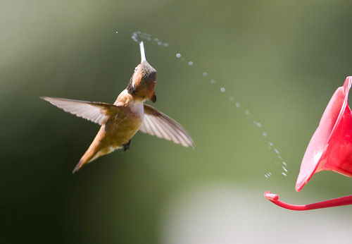
Whoopee! Rufous Hummingbird photo by Rick Leche


If your yard has hummingbirds, you've got more action than Smokey and the Bandit! More mischief than a barrel full of cairn terriers! Hummingbirds tear around the feeders like Steve McQueen in a green Mustang fastback! That's why many of us are counting the days till the little winged hellions return.

Which brings me to today's "Website Wednesday": hummingbird bander Lanny Chambers' web-site, Hummingbirds.net. Every time I write about hummingbirds, I have to give credit to Lanny. When I posted about the recapture of a Rufous Hummingbird with a record-breaking migration,  he told me, “This spectacular recapture is like a blind golfer making a hole-in-one on a million-yard hole! I've banded about 2500 hummers in 10 years. Exactly two have been recaptured elsewhere.” 

Over the years that I've known him, he's given me plenty of information about nectar feeders, which he makes available on the site. He explains why the structure of the feeder is important, as I mentioned in my post about feeders last August. He's given us information about hummingbird babies, and their look-alike neighbors, the hummingbird moths. For my post "They'd Rather Fight than Switch," Lanny told me about Dennis Demcheck's article, “Sugar Content of Hummingbird Plants in Louisiana Gardens.” Demcheck used a refractometer to measure the concentration of sugar in the nectar of blossoms in his garden—information used by many a hummingbird gardener to improve the crop!

Lanny's site was featured by the Librarians' Internet Index—now the Internet Public Library. The popular education website Journey North: A Global Study of Wildlife Migration and Seasonal Change asked him to write their Frequently Asked Questions page. He's a frequent contributor to the HumNet forum. His website includes information you'll have a hard time finding anywhere else, but my favorite page is the migration map. I check it often to see how close Ruby-throated Hummingbirds are to me. I always try to be the first in my area to report one to Lanny, but no luck so far. Last year, 4,122 people sent him a "first of the year" hummingbird report! 

Type "hummingbirds" into the Google search box and see what comes up first out of 3.25 million results. Go on—I dare you!

Wednesday, March 2, 2011

GAP: Gap Analysis Program

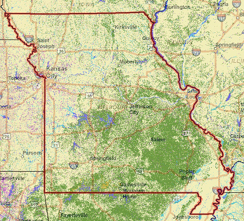
It's Website Wednesday again, but it's going to take me more than a week to study all the aspects of this site! GAP, or Gap Analysis Program is directed by the US Geological Survey. They coordinate with other agencies to create a database of information about the terrestrial and aquatic communities of plants and animals. This information is then mashed together and displayed on incredibly detailed maps.

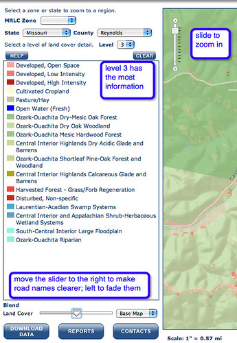
Click on "National Land Cover View and Data" at lower left to begin. From the pull-down menu, you can choose to see a state, or a certain county within a state.

Set the level of detail you'd like to see on the map. Level 1 displays 8 different descriptions of the areas, such as "Riparian and wetland systems." Get more information on Level 2, which displays up to 43 different types of plant communities, such as "Deciduous dominated savannah and glade." Level 3 can indicate up to 590 plant communities if they are present.


The purpose of the project is to reveal those plant communities which are underprotected.  For example, a state agency or organization could see which plant communities exist in the state, and which of these types are adequately represented in protected areas and which are not. Once a vulnerable plant or animal community is identified, the next step is to locate examples of this type. These maps can inform management decisions and help states prioritize which areas to protect.

This example is from Reynolds County, not far from The Nature Conservancy's Grasshopper Hollow. 17 ecotypes are listed. Grasshopper Hollow is a fascinating area of fens, with some rare plants and animals. In 2000, a breeding population of the endangered Hine's Emerald dragonfly was discovered here. It's also known for rare amphibians and orchids.


I couldn't resist snapping a screenshot one of my favorite spots in Missouri. It's interesting to see the official description of the ecotype of camp where I spent 20 summers. They're right. It is pretty dry. The rainwater runs into sink holes and losing streams among the limestone ledges. I wrote about one of those special places in "Wild Hydrangea."

Investigate your favorite spot, and check out your own neighborhood too. Learning about the natural habitat of the area can inform your decisions about your own yard or community garden, giving clues to which plants to include in a native plant garden.

Wednesday, February 2, 2011

Website Wed: My Google Maps


View Young Conservation Area in a larger map
Google maps are already pretty good, why would I want to create my own map? Well, you might want to direct birders to the spot where you glimpsed a mysterious bird--was it a Snowy Owl or a partially-albino (leucistic) Barred Owl? Maybe you have a new location for the botany group to visit on their next field trip. There's a new location for the annual banquet--here. You can do all this with Google's "My Maps." (You need a free Google account if you don't already have one.)
Save to… Create a new map
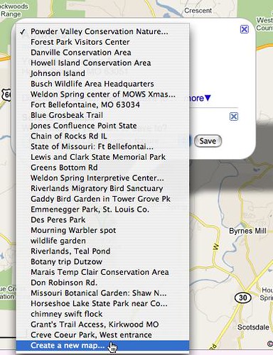
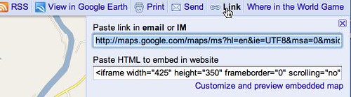
The easiest way to do this is to do a search for an address, but you can also just enter a location, such as Hilda Young Conservation Area. When I typed in the name, I got a map with thumbtacks in 6 results for my "Hilda Young" search--none of them correct. But when I adjusted the slider on the left of the map to zoom out to a larger view, I saw the conservation area. With a click, a balloon pops up offering "Save to…" I chose "create a new map." Now I can edit my own balloon, even add links. Once saved, on top right is "Link." Here I copy the link to paste into an email or set a link on a web page. Use the embed code if you want to embed it into your website and allow people to interact with the map as I have above.

Your "My Maps" have many uses. Send your visiting college roommate an email or instant message telling them how to get to your house--not recommended in public messages on Facebook. Use the link in your organization's newsletter or web page for the next meeting or banquet. When you find a rare bird, make a Google map and put it in the birding forum or list serve. If you post nature photos on Flickr, Flickr has a similar map function.
Copy the link to share it in email, or embed code for a website
My favorite use is to put the link in a Google calendar event. The map that links to the "where" field in your calendar event is chosen by Google automatically. However, if more than one location has the same or similar name, Google may link to the wrong one. Instead of typing the name in "where," you enter latitude and longitude. I don't have a GPS system, so I just type in an address and get the coordinates at iTouchMap.com. Then, in the field "Where," I put the numbers iTouchMap provided, followed by the place name in parentheses.